Green Shores | Resources
Glossary
A
Absorbent landscaping
Landscaping characterized by deeper, organic soils or in the case of forests, a thick duff cover. Soils in absorbent landscaping should have 10-25% organic content and minimum 300 mm (12 inches) depth. Absorbent landscapes incorporate herbaceous vegetation (shrubs, grasses with thick root mats) and trees.
Accretion
The gradual addition of sediment to a beach or to marsh surface as a result of deposition by flowing water or air. Accretion leads to the seaward building of the coastline or an increase in the elevation of a beach profile (the opposite of erosion) (Shipman 2008).
Armor/Armoring
Rigid, permanent design techniques used to stabilize shorelines and prevent erosion.
B
Backshore
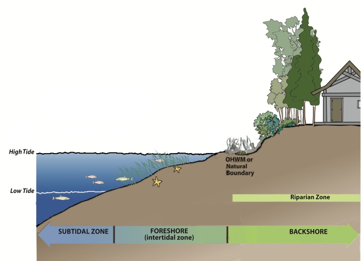
The upper zone of a beach (or land above the OHWM) beyond the reach of normal waves and tides, landward of the beach face. The backshore is subject to periodic flooding by storms and extreme tides, and is often the site of dunes and back-barrier wetlands (Figure 1).
Bank or Bluff
A steep slope rising from the shore, generally formed by erosion and mass wasting of poorly consolidated material such as glacial or fluvial sediments. In marine systems, the term bluff is typically used in the Pacific Northwest for a steep sea cliff composed of unconsolidated sediment that has no to moderate amounts of vegetation. The term bank is typically used in the Northwest for lower elevation sea cliff with a well vegetated bank face.
Beach
The gently-sloping zone of unconsolidated sediment along the shore that is moved by waves, wind, and tidal currents. Width is measured cross-shore from the break in slope between the upper beach and the low-tide terrace and the waterward extent of the backshore.
Berm
A low shelf or narrow terrace on the backshore of a beach formed of material thrown up and deposited by storm waves.
Boulder-cobble beach
A beach made up of a mixture of boulder and cobble gravel sediment. Boulder: a specific size class of gravel sediment greater than 256 mm (10.1 in) in median diameter. Cobble: a specific size class of gravel sediment 64-256 mm (2.5-10.1 in) in median diameter.
Building – major
Refers primarily to a house or primary residential building on a property.


Building – minor
Refers to secondary buildings on a property such as a garage, shed, gazebo, patio, deck, etc.
Bulkhead
A general term for shore armor structures that run parallel to the shore and designed to protect against wave attack or serve as a retaining wall. It includes seawalls, revetments, riprap, and gabions.
C
Climate change
Long‐term changes in average temperature, precipitation and weather events such as storm frequency and intensity.
D
Diameter at breast height (DBH)
A standard method of expressing the diameter of the trunk of a tree; commonly measured at 4.5 ft or 1.3 m from the ground.
Drift cell
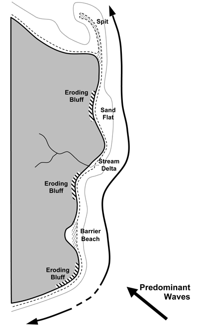
The nearshore area that includes a sediment source, a transport zone and a deposition zone (Figures 3 and 4). The cell boundaries delineate the geographical area within which the budget of sediment is balanced, providing the framework for the quantitative analysis of coastal erosion and accretion. Drift cells repeat along the shore, sometimes with smaller cells nesting in larger cells.


E
Ecosystem function
The natural processes and structures through which we benefit from shore environments such as production of forage fish or wave attenuation. Functions are roughly synonymous with goods and services.
Emergent vegetation
Plants that thrive in partially submerged conditions in freshwater environments. Examples of emergent plants are cattails, bulrushes and sedges.
Erosion
The wearing away of land by natural forces; pertaining to a beach, the carrying away of beach material by wave action, tidal currents, littoral currents, or wind action (opposite of accretion). Erosion may be long-term (occurs over decadal or greater scales) and short-term (occurs at less than decadal scale due to individual storm events or seasonal variability).
F
Feeder (or eroding) bluff
A bluff usually composed of glacial sediment that serves as sediment source for beaches in a drift cell. In the marine environment, it is a coastal bluff with active erosion and/or mass wasting that supplies moderate volumes of sediment to the nearshore. The bluff face typically has vegetation indicative of disturbance with evidence of landslides and toe erosion.
Fetch
Open water distance over which a wind can blow unimpeded and form waves.
Foreshore
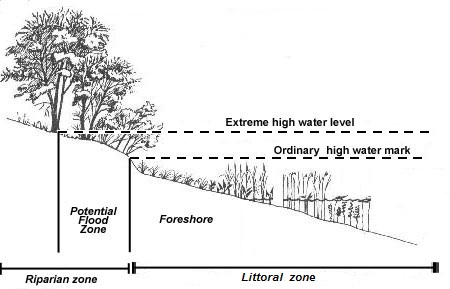
The area between high tide (or OHWM) and low tide water levels in marine systems (Figure 1), or between seasonal high water and low water levels on lakes (Figure 2).
G
Greenfield
A site or property that has never been developed; i.e., no buildings or infrastructure.
Gravel-sand beach
A beach made up of a mixture of gravel (rock fragments of 2-64 mm (0.08 – 10 in) median diameter) and sand (loose grains of 0.0625-2mm (0.0025-0.08 in) median diameter).
Groin
Shore structures that extend across the shore perpendicular to the shoreline with the intent of retarding erosion of a beach by trapping and retaining littoral sediment. Groins tend to trap sediment on the updrift side while “starving” sediment from the downdrift side of the groin.
I
Impervious
Not capable of transmitting or filtering water; instead, water runs off the surface.
Impervious surface area (ISA)
The area of a given lot or property that is covered by man-made structures such as rooftops, roads, sidewalks, driveways and parking lots that are covered by impenetrable materials such as shingles, asphalt, concrete, plastic, brick and stone. The ISA is often referred to as the built footprint.
Infrastructure
Structures that provide services for buildings or human activities. Major infrastructure refers to structures that provide essential services such as sewer, water lines, electrical, and cable services and roads. Minor infrastructure includes things such as driveways and walkways
Intertidal zone
In marine systems, the area between high tide and low tide levels (Figure 1).
L
Large woody debris (LWD)
Large logs with or without root masses attached, and can also include separate root masses.
Littoral zone
A general term referring to the part of the sea or lake that is close to the shore (Figure 2).
Littoral, longshore or net shore drift
Interchangeable terms that refer to the forces of erosion, transport, and deposition that combine to create movement of sediment parallel to the shore. These forces include waves that approach the shore at an angle, and a longshore current of water moving along the shoreline in the direction of wave movement. In marine systems, tidal currents are also involved. Sediment moves in a series of angled “in and out” directions that, overall, moves in a “net” direction along the shore.
Low impact development (LID)
Techniques and measures to reduce rainwater runoff, encourage rainwater infiltration into the ground, and remove any contaminants from runoff prior to flowing into receiving water bodies.
M
Monitoring
Observing the effect and/or effectiveness of an action to determine whether that action has a positive, negative or neutral effect on ecological or physical processes on the site. Monitoring can also indicate whether an action is having the desired effect, and whether any changes are required. Monitoring typically requires a record of “before” and “after” an activity is completed; it can also include project features or indicators than can be measured before and after construction.
N
Natural boundary
“The visible high water mark of any lake, stream, or other body of water where the presence and action of the water are so common and usual and so long continued in all ordinary years as to mark upon the soil of the bed of the lake, river stream, or other body of water a character distinct from that of the banks, both in vegetation and in the nature of the soil itself” (BC Land Act) (Figures 1 and 2).
Nearshore
A general term that encompasses the foreshore (intertidal) and shallow depth (subtidal) zones.
O
Ordinary high water mark (OHWM)
The highest level reached by a body of water that has been maintained for a sufficient period of time to leave evidence on the landscape (Figures 1 and 2). That evidence is “indicated by physical characteristics such as a clear, natural line impressed on the bank, shelving, changes in the character of soil, destruction of terrestrial vegetation, the presence of litter and debris, or other appropriate means that consider the characteristics of the surrounding areas.” (Federal Regulations 33 CFR 328.3(e)), Figure 2. In both marine and freshwater systems, the natural boundary or OHWM is usually the point at which natural vegetation shifts from hydrophytic (water-dependent) species to terrestrial species. This document uses OHWM most of the time, but this term is interchangeable with the term Natural Boundary.
Overhanging vegetation
Vegetation that extends at least a foot out over the water and provides shade for most of the day (unlike upright riparian vegetation that may throw a shadow only at certain times of day). Trees such as alder, native maples and willows and tall shrubs such as oceanspray and red-osier dogwood can become excellent overhanging species.
Overwater structure
Any built structure that extends over water such as a dock, pier or deck; can be on pilings or floating.
P
Permeable or pervious
Able to transmit or filter water.
R
Return wall
A section of bulkhead that extends towards land, typically from the end of a bulkhead, and ties into the bank or backshore.
Revetment
A hard armor technique using stone placed on a sloping bank to protect against waves or currents.
Riparian
Reference to the area immediately next to water that acts as an interface between water and land. The riparian area/zone is the transitional zone between the upland and aquatic environment where riparian vegetation is located (Figures 1 and 2).
Riparian buffer (RB)
The shoreline area that lies within the minimum riparian buffer OR setback required by the local jurisdiction OR within 35 ft/10 m of the OHWM (measured as the horizontal distance landward of the OHWM), whichever is greater.
Runup
The rush of waves up the face of a beach or structure produced by breaking waves. The maximum vertical height of water above still water level is the measure of runup.
S
Sea level rise (SLR)
The increase in sea level attributed to the effects of climate change.
Seawall
A shoreline armoring technique utilizing vertical or near vertical reinforced concrete or rock wall. Also referred to as a vertical bulkhead.
Setback
Distance of the nearest major building or infrastructure from the OHWM, or on bluff sites, measured from the bluff crest or break in slope landward.
Soft shore protection
Shore protection design which entails the use of indigenous materials such as gravel, sand, logs, and root masses in designs that have some degree of flexibility, mimicking natural processes.
Shore or shoreline protection structure
Any bulkhead, groin or other built structure used to protect a shoreline from erosions.
Storm surge
A rise of water associated with the influence of low pressure weather systems, wind setup, and wave setup.
Subtidal zone
In marine systems, the area below low tide level but still relatively shallow and close to shore, typically to a depth of about 35 feet/10 m (Figure 1).
W
Wrack or beach wrack
Organic material such as kelp and sea grass and other flotsam (plastic, glass, metal debris) that are cast up onto the beach by surf, tides, and wind. The “wrack line” usually marks the high tide line for that day. The organic portions of wrack provide food and habitat to many species that inhabit the shoreline, including insects and birds. Wrack also provides an incubator to grasses and other plants which grow along the shoreline and help to anchor dunes.


